HISTORIX Vintage 1905 The Nation's Capital and 50 similar items


Free Shipping
HISTORIX Vintage 1905 The Nation's Capital Map Poster - 16x16 Inch Vintage Map o
£28.70 GBP
View full item details »

Shipping options
Seller handling time is 1 business day Details
No shipping price specified to GB
Ships from
United States

Return policy
Full refund available for DOAs
Details
Purchase protection
Payment options
PayPal accepted
PayPal Credit accepted
Venmo accepted
PayPal, MasterCard, Visa, Discover, and American Express accepted
Maestro accepted
Amazon Pay accepted
Nuvei accepted
View full item details »
Shipping options
Seller handling time is 1 business day Details
No shipping price specified to GB
Ships from
United States
Return policy
Full refund available for DOAs
Details
Purchase protection
Payment options
PayPal accepted
PayPal Credit accepted
Venmo accepted
PayPal, MasterCard, Visa, Discover, and American Express accepted
Maestro accepted
Amazon Pay accepted
Nuvei accepted
Item traits
| Category: | |
|---|---|
| Quantity Available: |
8 in stock |
| Condition: |
New |
| UPC: |
705514889539 |
| MPN: |
ENMAP06651616 |
| EAN: |
0705514889539 |
| Color: |
Natural |
| binding: |
unbound |
| format: |
unbound |
| language: |
english |
| manufacturer: |
HISTORIX |
| Map Type: |
Historical |
| Externally Assigned Product Identifier: |
0705514889539 |
| Item Shape: |
Square |
| Bullet Point: | |
| Publication Date: |
1905T |
| Product Description: | |
| Brand: |
HISTORIX |
| Unspsc Code: |
55101500 |
| Paper Finish: |
matte |
| Map Scale: |
1000 |
| Item Name: | |
| Item Type Keyword: |
prints |
| Product Site Launch Date: |
2023-10-06T23:36:51.760Z |
| Paper Size: |
16 x 16 inches |
| Part Number: |
ENMAP06651616 |
Listing details
| Seller policies: | |
|---|---|
| Shipping discount: |
Seller pays shipping for this item. |
| Posted for sale: |
April 5 |
| Item number: |
1736380930 |
Item description
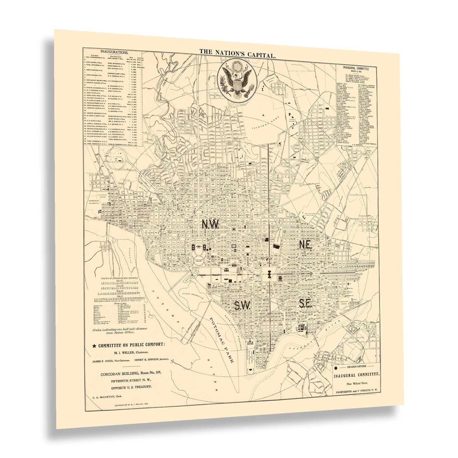
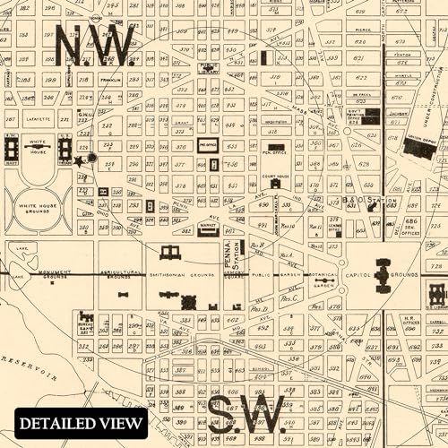
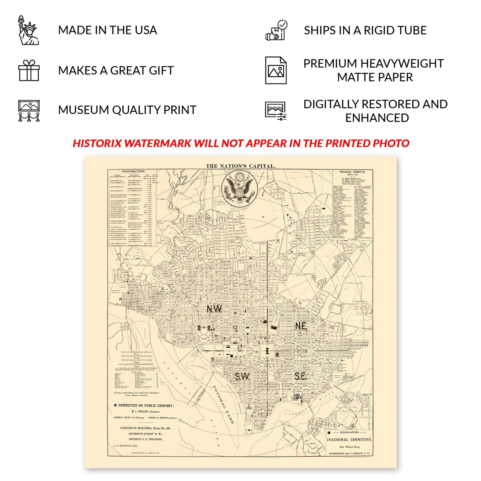
Located on the banks of the Potomac River and founded in 1791, the United States Capital, Washington DC, shares a border with Virginia and Maryland. However, it does not hold statehood and is formally referred to as the District of Columbia. Washington DC remains one of the nation's most influential political, cultural, and economic regions. It has a rich history that is intrinsically linked to some of the most critical moments in American history, both through legislation and political actions since its founding in the late eighteenth century. In July 1790, the Residence Act was approved and created the capital district on the eastern bank of the Potomac.
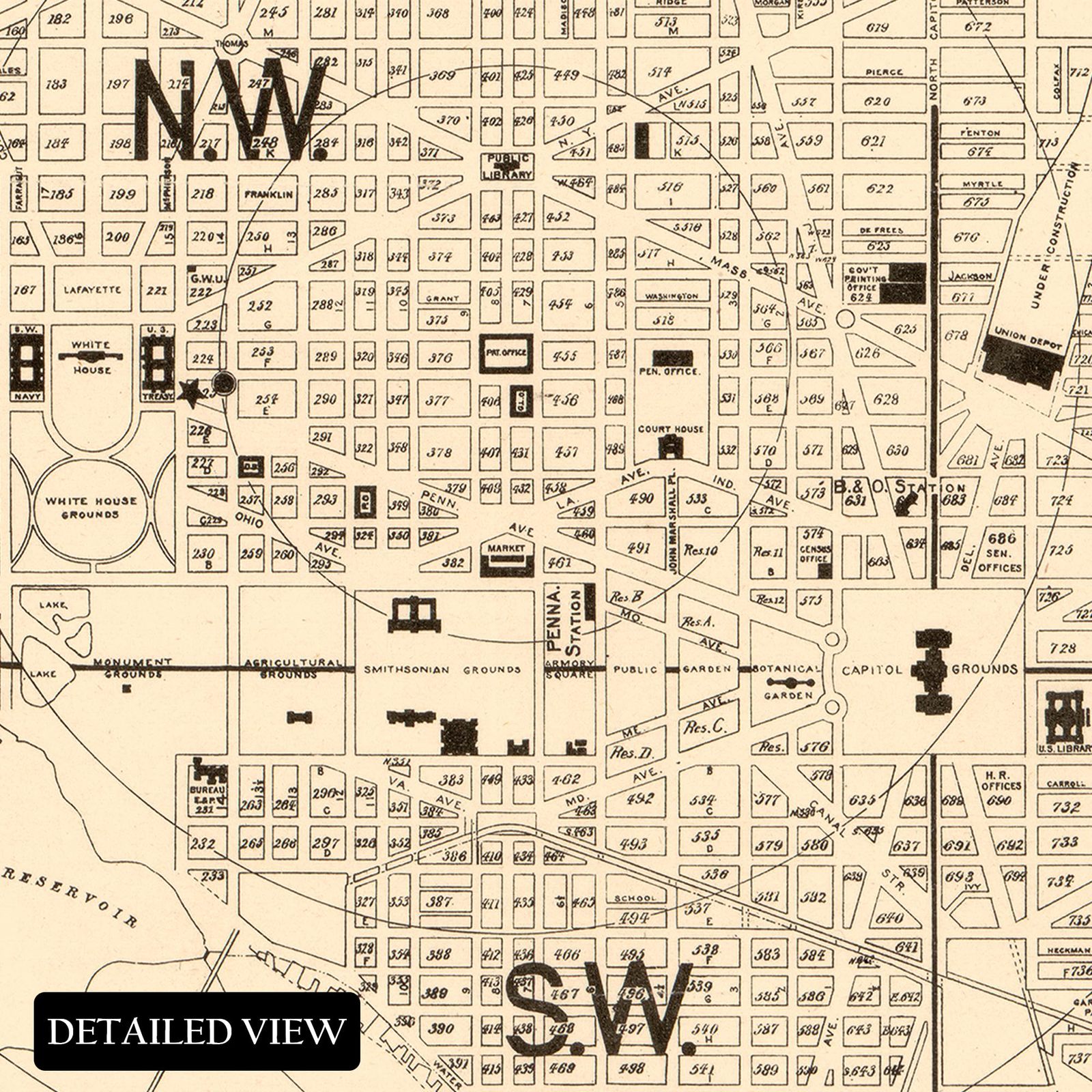
The city is divided into quadrants centered around the capital. It draws hundreds of thousands of tourists annually to tour the numerous museums, federal government buildings, other historical attractions, and the White House. Washington DC is home to all three branches of the federal government and came under attack by the British in the War of 1812 when English forces defeated American troops at Bladensburg and set numerous buildings alight, which led to significant damage to the United States Capital, the treasury Building, and the White House.
This map was produced in 1905 as the nation was experiencing a tremendous amount of growth and prosperity following the turn of the twentieth century following the economic expansion during the so-called Gilded Age of the late nineteenth century. This piece remains an enduring piece of American cartographical history.
Additional Details
------------------------------
Bullet point: VINTAGE MAP REPRODUCTION: You?ll love this high quality historic reproduction of 1905 The Nation's Capital Map Poster. Our museum quality prints are archival grade, which means it will look great and last without fading for over 100 years. Our print to order maps are made in the USA and each map is inspected for quality. This beautiful artwork is a perfect addition to your themed decor. Vintage maps look great in the home, study or office. They make a perfect gift as well.
Product description:
Located on the banks of the Potomac River and founded in 1791, the United States Capital, Washington DC, shares a border with Virginia and Maryland. However, it does not hold statehood and is formally referred to as the District of Columbia. Washington DC remains one of the nation's most influential political, cultural, and economic regions. It has a rich history that is intrinsically linked to some of the most critical moments in American history, both through legislation and political actions since its founding in the late eighteenth century. In July 1790, the Residence Act was approved and created the capital district on the eastern bank of the Potomac.
The city is divided into quadrants centered around the capital. It draws hundreds of thousands of tourists annually to tour the numerous museums, federal government buildings, other historical attractions, and the White House. Washington DC is home to all three branches of the federal government and came under attack by the British in the War of 1812 when English forces defeated American troops at Bladensburg and set numerous buildings alight, which led to significant damage to the United States Capital, the treasury Building, and the White House.
This map was produced in 1905 as the nation was experiencing a tremendous amount of growth and prosperity following the turn of the twentieth century following the economic expansion during the so-called Gilded Age of the late nineteenth century. This piece remains an enduring piece of American cartographical history.
Format: wall_map
|
Why are we showing these items?
Booth
Historic Prints |

|


-
Refine your browsing experience
We can show you more items that are exactly like the original item, or we can show you items that are similar in spirit. By default we show you a mix.


This item has been added to your cart
 HISTORIX Vintage 1905 The Nation's Capital Map Poster - 16x16 Inch Vintage Map o added to cart.
8 available in stock
HISTORIX Vintage 1905 The Nation's Capital Map Poster - 16x16 Inch Vintage Map o added to cart.
8 available in stock
View Cart or continue shopping.
 Please wait while we finish adding this item to your cart.
Get an item reminder
We'll email you a link to your item now and follow up with a single reminder (if you'd like one). That's it! No spam, no hassle.
Already have an account?
Log in and add this item to your wish list.