HISTORIX Vintage 1833 North Carolina State and 50 similar items


Free Shipping
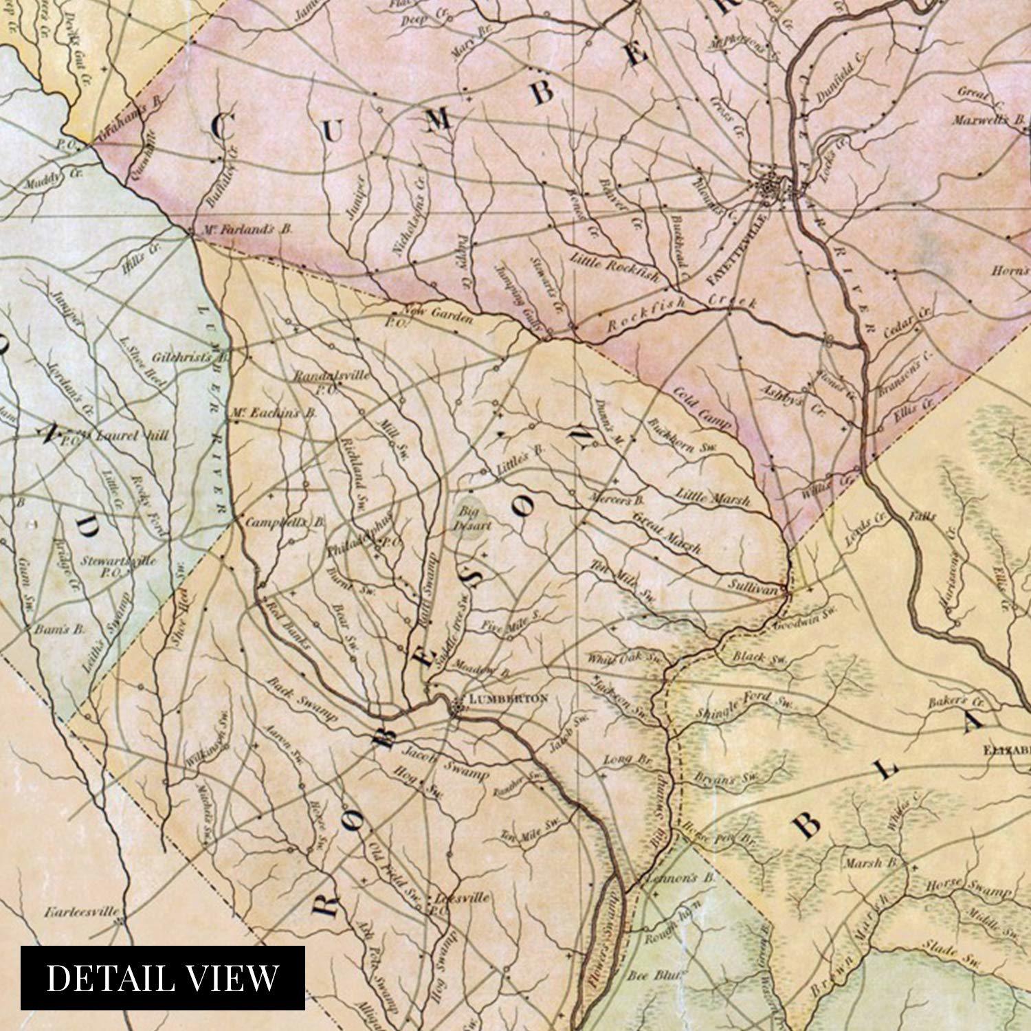
HISTORIX Vintage 1833 North Carolina State Map - 12x24 Inch North Carolina Vinta
£28.70 GBP - £56.66 GBP
View full item details »

Shipping options
Seller handling time is 1 business day Details
No shipping price specified to GB
Ships from
United States

Return policy
Full refund available for DOAs
Details
Purchase protection
Payment options
PayPal accepted
PayPal Credit accepted
Venmo accepted
PayPal, MasterCard, Visa, Discover, and American Express accepted
Maestro accepted
Amazon Pay accepted
Nuvei accepted
View full item details »
Shipping options
Seller handling time is 1 business day Details
No shipping price specified to GB
Ships from
United States
Return policy
Full refund available for DOAs
Details
Purchase protection
Payment options
PayPal accepted
PayPal Credit accepted
Venmo accepted
PayPal, MasterCard, Visa, Discover, and American Express accepted
Maestro accepted
Amazon Pay accepted
Nuvei accepted
Item traits
| Category: | |
|---|---|
| Quantity Available: |
15 in stock |
| Condition: |
New |
| ASIN: |
B089S8WHQQ |
| Item Name: |
HISTORIX 1833 A new map of the state of North Carolina |
| manufacturer: |
Historix |
| Item Type Keyword: |
prints |
| Brand: |
HISTORIX |
| Unspsc Code: |
60121013 |
| sizes: |
Listing details
| Seller policies: | |
|---|---|
| Shipping discount: |
Seller pays shipping for this item. |
| Posted for sale: |
April 15 |
| Item number: |
1739592791 |
Item description
Published by prolific English cartographer and civil engineer Robert Brazier, the distinctive aesthetic of this map immediately transports the viewer back in time. This period of transition for the state was giving North Carolinians greater access to shipping and railway transportation. While the eastern portion of the state became more cosmopolitan, the western regions remained largely agrarian, with tobacco production being the primary economic driver.
North Carolina had seen numerous battles during the American Revolution, including the pivotal conflict between Continental General Nathaniel Greene and British General Cornwallis. Cornwallis would ultimately be defeated by Greene’s troops at the Battle of Guilford Courthouse and retreat to the coast. Cornwallis would flee the state seeking refuge in Virginia. Eventually, the British General found himself surrounded by Continental and French troops and surrendered to General George Washington, effectively ending the American Revolution. North Carolina would join the United States in 1789, becoming the twelfth state of the Union.
As Railroads increased access in the 19th century, North Carolina saw a period of economic growth and expansion, and the completion of the Wilmington and Raleigh line saw interconnectivity for the coastal region and interior of the state. This line would become critical for the movement of goods throughout the state, especially in the latter portion of the 19th century. This depiction of North Carolina is an authentic piece of cartographical history, and the details allow historians to trace the evolution of the states rich history and culture, developing a sense for what daily life looked like in the early 19th century.
Our museum quality giclee print comes printed with archival ink on premium heavyweight matte paper. Shipped in a sturdy cardboard tube your print will arrive ready to be framed. This eye-catching vintage map reproduction print makes the perfect
|
Why are we showing these items?
Booth
Historic Prints |

|


-
Refine your browsing experience
We can show you more items that are exactly like the original item, or we can show you items that are similar in spirit. By default we show you a mix.


This item has been added to your cart
 HISTORIX Vintage 1833 North Carolina State Map - 12x24 Inch North Carolina Vinta added to cart.
15 available in stock
HISTORIX Vintage 1833 North Carolina State Map - 12x24 Inch North Carolina Vinta added to cart.
15 available in stock
View Cart or continue shopping.
 Please wait while we finish adding this item to your cart.
Get an item reminder
We'll email you a link to your item now and follow up with a single reminder (if you'd like one). That's it! No spam, no hassle.
Already have an account?
Log in and add this item to your wish list.