HISTORIX Vintage 1894 Alameda & Contra Costa and 50 similar items


Free Shipping
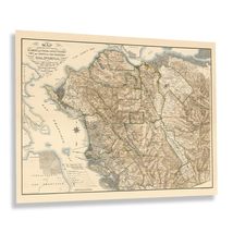
HISTORIX Vintage 1894 Alameda & Contra Costa Map Print - 18x24 Inch Old Map of A
£30.36 GBP
View full item details »

Shipping options
Seller handling time is 1 business day Details
No shipping price specified to GB
Ships from
United States

Return policy
Full refund available for DOAs
Details
Purchase protection
Payment options
PayPal accepted
PayPal Credit accepted
Venmo accepted
PayPal, MasterCard, Visa, Discover, and American Express accepted
Maestro accepted
Amazon Pay accepted
Nuvei accepted
View full item details »
Shipping options
Seller handling time is 1 business day Details
No shipping price specified to GB
Ships from
United States
Return policy
Full refund available for DOAs
Details
Purchase protection
Payment options
PayPal accepted
PayPal Credit accepted
Venmo accepted
PayPal, MasterCard, Visa, Discover, and American Express accepted
Maestro accepted
Amazon Pay accepted
Nuvei accepted
Item traits
| Category: | |
|---|---|
| Quantity Available: |
8 in stock |
| Condition: |
New |
| UPC: |
705514892126 |
| MPN: |
ENMAP06921824 |
| EAN: |
0705514892126 |
| Color: |
Natural |
| binding: |
unbound |
| format: |
unbound |
| language: |
english |
| manufacturer: |
HISTORIX |
| Map Type: |
Historical |
| Externally Assigned Product Identifier: |
0705514892126 |
| Bullet Point: | |
| Publication Date: |
1894T |
| Product Description: | |
| Brand: |
HISTORIX |
| Unspsc Code: |
55101500 |
| Paper Finish: |
matte |
| Map Scale: |
1000 |
| Item Name: | |
| Item Type Keyword: |
prints |
| Product Site Launch Date: |
2024-02-19T07:41:53.134Z |
| Paper Size: |
18 x 24 inches |
| Part Number: |
ENMAP06921824 |
Listing details
| Seller policies: | |
|---|---|
| Shipping discount: |
Seller pays shipping for this item. |
| Posted for sale: |
April 3 |
| Item number: |
1735828148 |
Item description
Alameda and Contra Costa Counties have been essential areas in California's Northern Coast for centuries as the regions developed with bustling ports. This map was produced in a period of significant growth and prosperity, which the region had enjoyed since the middle of the nineteenth century when vast gold reserves were discovered in the Sierra Nevada Mountains, bringing considerable wealth to the cities as a banking hub on the West Coast. During the nineteenth century, San Francisco rivaled Los Angeles, Seattle, and Portland, Oregon, as a trading port for goods being imported to the United States from Asia and exporting American-made goods to foreign markets.
As the nation approached the turn of the century, the Bay Area, along with the rest of the country, was being transformed in the years of the Industrial Revolution and a period of peace following the conclusion of the American Civil War in addition to technological advances in transportation, architecture, and culture as America became one of the most influential nations in the world and continued to develop. This map was produced by the prolific San Francisco-based lithography firm Britton Rey, who created numerous works during the nineteenth century.
This map's distinctive style and classic aesthetic immediately transport the viewer back in time, creating a lasting bond between the past and present that illustrates the evolution and growth of the region through the following centuries. This is an authentic piece of cartographical history.
Additional Details
------------------------------
Bullet point: VINTAGE MAP REPRODUCTION: You?ll love this high quality historic reproduction of 1894 Alameda Contra Costa Map Print. Our museum quality prints are archival grade, which means it will look great and last without fading for over 100 years. Our print to order maps are made in the USA and each map is inspected for quality. This beautiful artwork is a perfect addition to your themed decor. Vintage maps look great in the home, study or office. They make a perfect gift as well.
Product description:
Alameda and Contra Costa Counties have been essential areas in California's Northern Coast for centuries as the regions developed with bustling ports. This map was produced in a period of significant growth and prosperity, which the region had enjoyed since the middle of the nineteenth century when vast gold reserves were discovered in the Sierra Nevada Mountains, bringing considerable wealth to the cities as a banking hub on the West Coast. During the nineteenth century, San Francisco rivaled Los Angeles, Seattle, and Portland, Oregon, as a trading port for goods being imported to the United States from Asia and exporting American-made goods to foreign markets.
As the nation approached the turn of the century, the Bay Area, along with the rest of the country, was being transformed in the years of the Industrial Revolution and a period of peace following the conclusion of the American Civil War in addition to technological advances in transportation, architecture, and culture as America became one of the most influential nations in the world and continued to develop. This map was produced by the prolific San Francisco-based lithography firm Britton Rey, who created numerous works during the nineteenth century.
This map's distinctive style and classic aesthetic immediately transport the viewer back in time, creating a lasting bond between the past and present that illustrates the evolution and growth of the region through the following centuries. This is an authentic piece of cartographical history.
Format: wall_map
|
Why are we showing these items?
Booth
Historic Prints |

|


-
Refine your browsing experience
We can show you more items that are exactly like the original item, or we can show you items that are similar in spirit. By default we show you a mix.


This item has been added to your cart
 HISTORIX Vintage 1894 Alameda & Contra Costa Map Print - 18x24 Inch Old Map of A added to cart.
8 available in stock
HISTORIX Vintage 1894 Alameda & Contra Costa Map Print - 18x24 Inch Old Map of A added to cart.
8 available in stock
View Cart or continue shopping.
 Please wait while we finish adding this item to your cart.
Get an item reminder
We'll email you a link to your item now and follow up with a single reminder (if you'd like one). That's it! No spam, no hassle.
Already have an account?
Log in and add this item to your wish list.