HISTORIX Vintage 1883 Mandan North Dakota Map Poster - Old Bird's Eye View of Ma
Ships from
United States

Shipping options
Seller handling time is 1 business day Details
This reflects the seller's handling time and may not include time spent in transit.
If you have questions about shipping, please contact the seller.
No shipping price specified to GB
Ships from
United States
Return policy
Full refund available for DOAs
Details
- We guarantee our products and offer full refunds or exchange for defective items or items not as-described.
- Buyer must contact us within 30 days after receipt of shipment.
- The item must be received in the same condition as shipped.
- Items must be returned with all original packaging and accessories.
- Items must not be abused, modified or damaged by accident.
- A 20% restocking fee will be charged for returns
- Buyer is responsible for all return shipping and handling fees.
- Restocking and return shipping fees do not apply when item is returned as defective or because incorrect product was delivered.
Payment options
PayPal accepted
PayPal Credit accepted
Venmo accepted
PayPal, MasterCard, Visa, Discover, and American Express accepted
Maestro accepted
Amazon Pay accepted
Nuvei accepted
Item traits
| Category: |
Kitchen Scales
|
| Quantity Available: |
16 in stock
|
| Condition: |
New
|
| ASIN: |
B0C4DB2Z3M
|
| Color: |
Natural
|
| Bullet Point: |
View details
VINTAGE MAP REPRODUCTION: You’ll love this high quality historic reproduction of 1883 Mandan North Dakota Map Poster. Our museum quality prints are archival grade, which means it will look great and last without fading for over 100 years. Our prin...
|
| theme: |
Vintage
|
| Product Description: |
View details
Located on the western banks of the Upper Missouri River, which served as the primary transportation access to the region before the establishment of rail lines throughout the region. Regular steamboat service began in the river in the 1830s an...
|
| Brand: |
HISTORIX
|
| orientation: |
Landscape
|
| Item Name: |
View details
HISTORIX Vintage 1883 Mandan North Dakota Map Poster - Old Bird's Eye View of Mandan City Morton County North Dakota State Map Wall Art
|
| Item Type Keyword: |
prints
|
| sizes: |
View details
16x24 Inch (8 in stock)
24x36 Inch (8 in stock)
|
Listing details
|
Seller policies:
|
View seller policies
|
|
Shipping discount:
|
Seller pays shipping for this item.
|
|
Posted for sale:
|
April 29
|
|
Item number:
|
1743203539
|
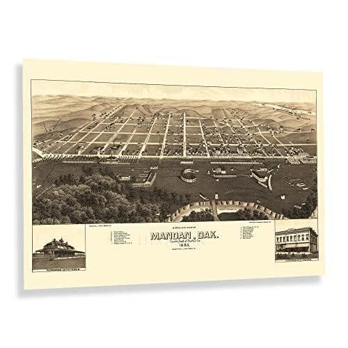
Located on the western banks of the Upper Missouri River, which served as the primary transportation access to the region before the establishment of rail lines throughout the region. Regular steamboat service began in the river in the 1830s and continued throughout the nineteenth century providing a way for goods and residents to access the growing town. In the years following the conclusion of the American Civil War, numerous groups of immigrants from across the United States and Eastern and Western Europe established neighborhoods and communities in the region based on cultural lines, many of which exist to this day.
Bellows Landing was established in the river by the Army Corps of Engineers, which also installed dry docks and boat repair areas during the 1870s. These landings supported supply ships for the US Army's frontier forts and, at the time, was considered the best landing in the area. One distinction for these landings was that they were safe to use year-round, even during the spring when ice was broken up to allow passage. The city was only officially incorporated two years before this panoramic map's publication, and the city began to become an important transportation hub and allowed for farmers and ranchers to get agricultural products to markets in Chicago and the Northeast.
Produced and published by Joseph John Stoner with his longtime collaborators Beck Pauli, this birds-eye perspective bears a distinctive aesthetic and unique style that immediately transports the viewer back in time, creating an indelible bond to the past.
Additional Details
------------------------------
Bullet point: VINTAGE MAP REPRODUCTION: You?ll love this high quality historic reproduction of 1883 Mandan North Dakota Map Poster. Our museum quality prints are archival grade, which means it will look great and last without fading for over 100 years. Our print to order maps are made in the USA and each map is inspected for quality. This beautiful artwork is a perfect addition to your themed decor. Vintage maps look great in the home, study or office. They make a perfect gift as well.
Product description:
Located on the western banks of the Upper Missouri River, which served as the primary transportation access to the region before the establishment of rail lines throughout the region. Regular steamboat service began in the river in the 1830s and continued throughout the nineteenth century providing a way for goods and residents to access the growing town. In the years following the conclusion of the American Civil War, numerous groups of immigrants from across the United States and Eastern and Western Europe established neighborhoods and communities in the region based on cultural lines, many of which exist to this day.
Bellows Landing was established in the river by the Army Corps of Engineers, which also installed dry docks and boat repair areas during the 1870s. These landings supported supply ships for the US Army's frontier forts and, at the time, was considered the best landing in the area. One distinction for these landings was that they were safe to use year-round, even during the spring when ice was broken up to allow passage. The city was only officially incorporated two years before this panoramic map's publication, and the city began to become an important transportation hub and allowed for farmers and ranchers to get agricultural products to markets in Chicago and the Northeast.
Produced and published by Joseph John Stoner with his longtime collaborators Beck Pauli, this birds-eye perspective bears a distinctive aesthetic and unique style that immediately transports the viewer back in time, creating an indelible bond to the past.