HISTORIX Vintage 1862 Fredericksburg Virginia Map Print - 16x24 Inch Vintage Map
Ships from
United States

Shipping options
Seller handling time is 1 business day Details
This reflects the seller's handling time and may not include time spent in transit.
If you have questions about shipping, please contact the seller.
No shipping price specified to GB
Ships from
United States
Return policy
Full refund available for DOAs
Details
- We guarantee our products and offer full refunds or exchange for defective items or items not as-described.
- Buyer must contact us within 30 days after receipt of shipment.
- The item must be received in the same condition as shipped.
- Items must be returned with all original packaging and accessories.
- Items must not be abused, modified or damaged by accident.
- A 20% restocking fee will be charged for returns
- Buyer is responsible for all return shipping and handling fees.
- Restocking and return shipping fees do not apply when item is returned as defective or because incorrect product was delivered.
Payment options
PayPal accepted
PayPal Credit accepted
Venmo accepted
PayPal, MasterCard, Visa, Discover, and American Express accepted
Maestro accepted
Amazon Pay accepted
Nuvei accepted
Item traits
| Category: |
Laminating Machines
|
| Quantity Available: |
16 in stock
|
| Condition: |
New
|
| ASIN: |
B0C9V9ZHYH
|
| color: |
Natural
|
| Bullet Point: |
View details
VINTAGE MAP REPRODUCTION: You’ll love this high quality historic reproduction of 1862 Fredericksburg Virginia Map Print. Our museum quality prints are archival grade, which means it will look great and last without fading for over 100 years. Our p...
|
| Product Description: |
View details
Located on the Rappahannock River, where it crosses the Atlantic Seaboard fall line, Fredericksburg was a vital port during the Colonial Era. Some fifty miles southwest of Washington D.C., and almost equidistant to Richmond, Virginia, Frederick...
|
| Brand: |
HISTORIX
|
| Supplier Declared Dg Hz Regulation: |
not_applicable
|
| Item Name: |
View details
HISTORIX Vintage 1862 Fredericksburg Virginia Map Print - Vintage Map of Virginia Poster - Old View of Fredericksburg VA Map
|
| Item Type Keyword: |
wall-maps
|
| sizes: |
View details
16x24 Inch (8 in stock)
24x36 Inch (8 in stock)
|
Listing details
|
Seller policies:
|
View seller policies
|
|
Shipping discount:
|
Seller pays shipping for this item.
|
|
Posted for sale:
|
April 15
|
|
Item number:
|
1739668172
|
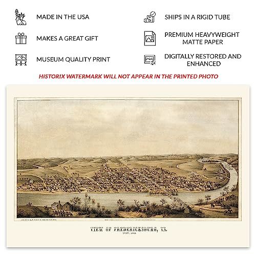
Located on the Rappahannock River, where it crosses the Atlantic Seaboard fall line, Fredericksburg was a vital port during the Colonial Era. Some fifty miles southwest of Washington D.C., and almost equidistant to Richmond, Virginia, Fredericksburg played a pivotal role in the American Civil War as the halfway point between Union and Confederate Capitols. This map was produced one year into the conflict by one of the early pioneers of the bird's eye perspective form Edward Sachse. Sacshe was born in Germany before immigrating to the United States, where he settled in Baltimore. His work is highly regarded for its color work and intricate details, along with artistic flourishes.
Fredericksburg was the site of two significant battles during the Civil War as it was an important port for the Confederacy and an early target for Union Forces coming from the North. Following the conclusion of the Civil War, Fredericksburg regained its economic status though it would take some years for it to reach pre-war population levels. The city maintained a flourishing economy during the nineteenth century with the establishment of numerous mills and manufacturing facilities being built on the river's banks, which attracted immigrants from across Western Europe who established neighborhoods and communities based on shared cultural heritage, many of which exist to this day.
Bird's eye perspectives bear a distinctive aesthetic that immediately transports the viewer back in time, creating an indelible bond between the past and present. This map shows the city in a period of significant transformation.
Additional Details
------------------------------
Bullet point: VINTAGE MAP REPRODUCTION: You?ll love this high quality historic reproduction of 1862 Fredericksburg Virginia Map Print. Our museum quality prints are archival grade, which means it will look great and last without fading for over 100 years. Our print to order maps are made in the USA and each map is inspected for quality. This beautiful artwork is a perfect addition to your themed decor. Vintage maps look great in the home, study or office. They make a perfect gift as well.
Product description:
Located on the Rappahannock River, where it crosses the Atlantic Seaboard fall line, Fredericksburg was a vital port during the Colonial Era. Some fifty miles southwest of Washington D.C., and almost equidistant to Richmond, Virginia, Fredericksburg played a pivotal role in the American Civil War as the halfway point between Union and Confederate Capitols. This map was produced one year into the conflict by one of the early pioneers of the bird's eye perspective form Edward Sachse. Sacshe was born in Germany before immigrating to the United States, where he settled in Baltimore. His work is highly regarded for its color work and intricate details, along with artistic flourishes.
Fredericksburg was the site of two significant battles during the Civil War as it was an important port for the Confederacy and an early target for Union Forces coming from the North. Following the conclusion of the Civil War, Fredericksburg regained its economic status though it would take some years for it to reach pre-war population levels. The city maintained a flourishing economy during the nineteenth century with the establishment of numerous mills and manufacturing facilities being built on the river's banks, which attracted immigrants from across Western Europe who established neighborhoods and communities based on shared cultural heritage, many of which exist to this day.
Bird's eye perspectives bear a distinctive aesthetic that immediately transports the viewer back in time, creating an indelible bond between the past and present. This map shows the city in a period of significant transformation.