HISTORIX Vintage 1861 State of Missouri Map - 18x24 Inch Vintage Map of Missouri
Ships from
United States

Shipping options
Seller handling time is 1 business day Details
This reflects the seller's handling time and may not include time spent in transit.
If you have questions about shipping, please contact the seller.
No shipping price specified to GB
Ships from
United States
Return policy
Full refund available for DOAs
Details
- We guarantee our products and offer full refunds or exchange for defective items or items not as-described.
- Buyer must contact us within 30 days after receipt of shipment.
- The item must be received in the same condition as shipped.
- Items must be returned with all original packaging and accessories.
- Items must not be abused, modified or damaged by accident.
- A 20% restocking fee will be charged for returns
- Buyer is responsible for all return shipping and handling fees.
- Restocking and return shipping fees do not apply when item is returned as defective or because incorrect product was delivered.
Payment options
PayPal accepted
PayPal Credit accepted
Venmo accepted
PayPal, MasterCard, Visa, Discover, and American Express accepted
Maestro accepted
Amazon Pay accepted
Nuvei accepted
Item traits
| Category: |
Kitchen Scales
|
| Quantity Available: |
16 in stock
|
| Condition: |
New
|
| ASIN: |
B089G58G6D
|
| Item Name: |
HISTORIX 1861 Missouri State
|
| manufacturer: |
Historix
|
| Item Type Keyword: |
prints
|
| Product Site Launch Date: |
2020-05-31T14:58:34.744Z
|
| Brand: |
HISTORIX
|
| Unspsc Code: |
60121013
|
| sizes: |
View details
18x24 Inch (8 in stock)
24x30 Inch (8 in stock)
|
Listing details
|
Seller policies:
|
View seller policies
|
|
Shipping discount:
|
Seller pays shipping for this item.
|
|
Posted for sale:
|
April 17
|
|
Item number:
|
1740300311
|
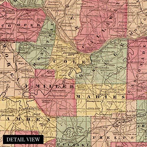
General map of the state indicating county names and boundaries, cities and towns, railroads in operation and projected, roads, and rivers.
Published in the same year as the Battle of Wilson’s Creek, the first major conflict between Union and Confederacy forces in the Trans-Mississippi Theater of the Civil War, this depiction of the state of Missouri shows it just as the war broke out. Though the state was officially neutral in the Civil War, Confederate forces were victorious in this battle. They would maintain a prominent presence in the southwest portion of the state until the conclusion of the Civil War in 1865.
Missouri experienced a time of significant growth following the war spurred on by Kansas City, becoming an important railroad hub unlocking access to the American West. The stockyards in KansasCity became some of the largest in the nation as livestock traveled north for processing in the meat plants of Chicago. This access allowed arable land in the West fo be opened up for farming and ranching.
By 1860 St. Louis’ population had reached 4 million, and the city was flourishing with significant amounts of goods flowing up and down the Mississippi River. St Louis became a popular stopping point for merchants. The 1850s saw the rise of Steamboats traveling the river and would create some of the most iconic images of mid 19th century American History. Published by prolific American cartographer James T. Lloyd, this detailed depiction of Missouri, possesses a distinctive aesthetic that transforms the viewer back in time and is an authentic piece of cartographical as well as American History.
Our museum quality giclee print comes printed with archival ink on premium heavyweight matte paper. Shipped in a sturdy cardboard tube your print will arrive ready to be framed. This eye-catching vintage map reproduction print makes the perfect gift for anyone that loves history and imagery.