- We guarantee our products and offer full refunds or exchange for defective items or items not as-described.
- Buyer must contact us within 30 days after receipt of shipment.
- The item must be received in the same condition as shipped.
- Items must be returned with all original packaging and accessories.
- Items must not be abused, modified or damaged by accident.
- A 20% restocking fee will be charged for returns
- Buyer is responsible for all return shipping and handling fees.
- Restocking and return shipping fees do not apply when item is returned as defective or because incorrect product was delivered.
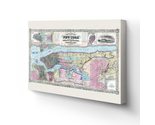
As tensions heated between Northern and Southern states leading up to the Civil War, New York City was flourishing as the cultural capital of the United States with bars and nightclubs like the Haymarket and McGlory's providing ecstatic crowds entertainment. This depiction illustrates the rapid development and population expansion that occurred in the iconic American City before 1861 when all American's lives were transformed when the Civil War broke out. The city remained divided regarding the issues underlying the Civil War.
As the railroad connection carried goods overland, the completion of the Erie Canal decades earlier had allowed the already booming ports of New York to maintain their financial dominance. The ports were vital to the region, and the thousands of immigrants that entered through them became an integral part of the cities culture. Irish immigrants were flooding in due to the famine occurring in their homeland, and Germans' fleeing revolt and upheaval respectively formed nearly half of the population at the time. The city had already surpassed the million resident mark and has remained the largest and most densely populated city in the United States.
This map depicts streets, rail lines, and proprietors names for river piers, which allow historians to develop a better understanding of the iconic cities' history and evolution. Published by JH Colton, who was one of the preeminent American mapmakers. The Colton Company was an international leader in the map publishing industry at the time; the distinct aesthetic and details immediately transport the viewer back in time.
Our ready-to-hang canvas wall art prints are made in the USA using the highest quality materials with professional craftsmanship. This beautiful artwork is a perfect addition to your themed decor. Historic prints look great in the home, study or office. They also make an unforgettable gift.