Civil War MAP-PLATE 114-ATLAS Official and 50 similar items
CIVIL WAR MAP-PLATE 114-ATLAS OFFICIAL RECORD,1893,DEFENSES NASHVILLE, DONELSON
£75.12 GBP
View full item details »
Shipping options
Seller handling time is 2 business days Details
No shipping price specified to GB
Ships from
United States

Return policy
None: All purchases final
Details
Purchase protection
Payment options
PayPal accepted
PayPal Credit accepted
Venmo accepted
PayPal, MasterCard, Visa, Discover, and American Express accepted
Maestro accepted
Amazon Pay accepted
Nuvei accepted
View full item details »
Shipping options
Seller handling time is 2 business days Details
No shipping price specified to GB
Ships from
United States
Return policy
None: All purchases final
Details
Purchase protection
Payment options
PayPal accepted
PayPal Credit accepted
Venmo accepted
PayPal, MasterCard, Visa, Discover, and American Express accepted
Maestro accepted
Amazon Pay accepted
Nuvei accepted
Item traits
| Category: | |
|---|---|
| Quantity Available: |
Only one in stock, order soon |
| Condition: |
Very Good |
| Type: |
Map |
| Original/Reproduction: |
Original |
| Date Range: |
1800-1899 |
| Format: |
Atlas Map |
| Printing Technique: |
Lithography |
Listing details
| Seller policies: | |
|---|---|
| Shipping discount: |
No combined shipping offered |
| Posted for sale: |
More than a week ago |
| Item number: |
1093455781 |
Item description
This plate came from The Atlas to Accompany the Official
Records of the Union and Confederate Armies. The Atlas
was published between 1891 and 1895 and is the definitive
source of Civil War information available. . Of the only 10,000 Published, less than 1,000 Complete Atlases Remain.
This Plate contains the following map(s).
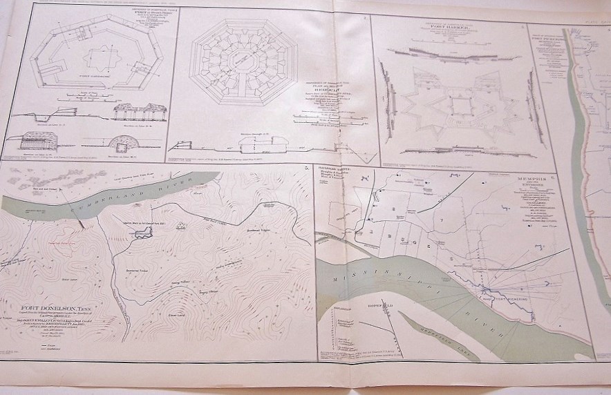
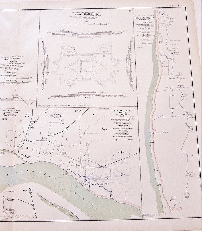
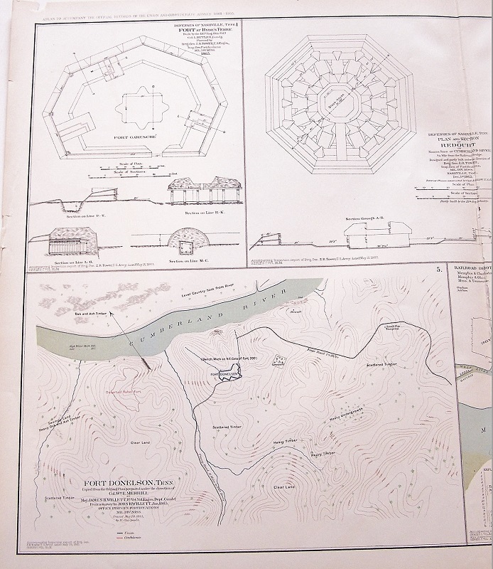
Plate CXIV
1. Defenses of Nashville, Tenn. Fort at Hyde's Ferry;
2. Defenses of Nashville, Tenn. Plan and Section of Redoubt;
3. Defenses of Nashville, Tenn. Fort Harker;
4. Trace of Interior Crest Fort Pickering, Memphis, Tenn.;
5. Fort Donelson, Tenn.;
6. Memphis and its Environs.
Made by The War Records Office, 1893-color lithograph-about 19 inches by 29 inches.
Map is in Very Good condition. Single fold as issued. Not a Reproduction. Original Lithograph Engraved by Julius Bien for the "The Official Atlas to Accompany the Official Records of the Union and Confederate Armies;" Commissioned by Resolution of Congress May 19, 1864, in accordance to serve


-
Refine your browsing experience
We can show you more items that are exactly like the original item, or we can show you items that are similar in spirit. By default we show you a mix.


This item has been added to your cart
 CIVIL WAR MAP-PLATE 114-ATLAS OFFICIAL RECORD,1893,DEFENSES NASHVILLE, DONELSON added to cart.
Only one available in stock
CIVIL WAR MAP-PLATE 114-ATLAS OFFICIAL RECORD,1893,DEFENSES NASHVILLE, DONELSON added to cart.
Only one available in stock
View Cart or continue shopping.
 Please wait while we finish adding this item to your cart.
Get an item reminder
We'll email you a link to your item now and follow up with a single reminder (if you'd like one). That's it! No spam, no hassle.
Already have an account?
Log in and add this item to your wish list.